Showing posts with label James Gibson. Show all posts

Saturday, September 22, 2018

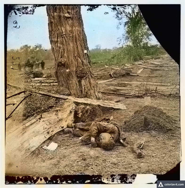
Antietam in color: Breathing life into 1862 battlefield images

Body of unknown Confederate next to grave of Michigan Lieutenant John Clark. (Library of Congress)
CLICK ON ALL IMAGES TO ENLARGE | COLORIZED BY ALGORITHMIA
Confederate dead near Dunker Church and West Woods. (Library of Congress
Like this blog on Facebook | Algorithmia colorization site.

Because of the limitations of the medium during the Civil War, photography wasn't produced in color. To add realism, soldier portraits sometimes were hand-colored or tinted by specialists, with varying results. Some battlefield photographs by Alexander Gardner -- whose images of Antietam dead fascinated, and horrified, the public 156 years ago -- were hand-colored. As seen in these two Antietam stereoviews from Center For Civil War Photography president Bob Zeller's collection, the results were less than spectacular.

Hand-colored Alexander Gardner stereoview view of Union burial crew at Antietam.
(Bob Zeller collection)
Colorized image by Alexander Gardner of Joseph Sherrick farm at Antietam.
(Bob Zeller collection) 
Unlike the cumbersome 19th-century process, colorization of black-and-white images is only a click away for us today. Using the Algorithmia site, I colorized Antietam images by Gardner and James Gibson, all available for your inspection in black and white in jpg. and tif formats on the fine Library of Congress web site.

Crude, crass ... or captivating? Let me know what you think.

James Gibson view of Middle Bridge from bluff above Antietam Creek. (Library of Congress)
Burnside Bridge, heavily contested on morning, early afternoon of Sept. 17, 1862. (Library of Congress)
Fallen Confederates arranged for burial. (Library of Congress)
Confederate dead along Hagerstown Pike. (Library of Congress)
Another view of Confederate dead along Hagerstown Pike ...  (Library of Congress)
... and more Confederate dead, also along Hagerstown Pike. (Library of Congress)
Confederate dead on the southern end of the battlefield. (Library of Congress)
Fallen Confederate in a ditch. (Library of Congress)
A Union soldier poses near Burnside Bridge by the graves of his comrades. (Library of Congress)

-- Have something to add (or correct) in this post? E-mail me here.

Saturday, April 21, 2018

Antietam Then & Now: James Gibson's Middle Bridge photo


          THEN: James Gibson, September 1862, LOC  | NOW:: John Banks, April 21, 2018.
           Hover on image to view "Now" photo. Does does not work on phones, tablets.

Like this blog on Facebook

After the Battle of Antietam in September 1862, James Gibson photographed the Middle Bridge, used extensively by both armies, from a steep bluff on the east bank of Antietam Creek. After securing permission from the land owner, I aimed to duplicate Gibson's long-ago image. As you can see in the "Now" photograph, the terrain has changed significantly since 1862. Not only is the hillside extensively wooded, the Middle Bridge  no longer exists. Destroyed by a flood in 1891, it has long since been replaced by a modern bridge built higher than the older span. For a re-examination of Gibson's image on my blog, go here.

-- Have something to add (or correct) in this post? E-mail me here.

Wednesday, August 09, 2017

Antietam: Re-examining Gibson's image of Middle Bridge

Middle Bridge over Antietam Creek (James Gibson | Library of Congress)
(CLICK ON ALL IMAGES TO ENLARGE)

 Like this blog on Facebook | Follow me on Twitter

Days after the Battle of Antietam, Alexander Gardner and James Gibson photographed the Middle Bridge, also known as Antietam Bridge, on the Boonsboro Pike. Although little fighting took place in this area, thousands of troops crossed over Antietam Creek here, perhaps the reason the photographers chose it for subject matter. (The bridge, built in the early 1800s, was destroyed by flood in 1891. A modern bridge crosses the creek today.)

On initial inspection, this Gibson image, taken from a steep bluff on the east bank of Antietam Creek, is unremarkable. But cropped enlargements of the photograph, available in high-resolution format on the Library of Congress web site, reveal cool details you may not have noticed. Click on the image above to enlarge -- the famous East Woods, where fighting raged on Sept. 17, 1862, appear in the right background, just above the farm buildings. Traveling west (to the left), the village of Sharpsburg is about two miles down the turnpike.

What else do you see?

... the ghost-like image of a man, his elbow resting upon the bridge near its east end. To his right, a large piece of cloth or canvas. What could that be?

.... several feet from the man leaning against the bridge, another ghost-like figure and what appears to be a barrel resting on some type of implement ....

.... toward the west end of the bridge, we find three human-like forms, each looking like the grainy figures that appeared in a Nov. 22, 1963 photograph of that infamous grassy knoll in Dallas. ...

.... at the far west end of the bridge, a covered wagon and a horse ...

... at the bottom of the image, this unusual object appears. What was it used for?


... a skiff on the eastern bank of Antietam Creek ...

... and on land in the background, on the west side of the creek, split-rail fencing, apparently with little damage ...


... and in the middle background, more fencing, apparently undamaged. A short distance over the ridge, a sunken road infamously known today as Bloody Lane ...

... and in the upper right, the farmhouse, barn and outbuildings used by tenant farmer Joseph Parks.  During the battle, the farm was well within Federal lines, but no significant action took place there. The farm may have been used as a hospital after the battle, although definitive information could not be found. Accessible to battlefield visitors, the farm is rarely visited. Below are present-day images of the Parks barn and farmhouse (in background). To visit the farm, park at the war-time Joshua Newcomer House on the west side of Antietam Creek and follow the signage for the 3 Farms Trail.

The barn and farmhouse are believed to have been constructed in the 1830s.

Have something to add (or correct) in this post? E-mail me here.