Like this blog on Facebook | Follow me on Twitter
 |
| Here's info on how to join the Battle of Nashville Trust. (I am on the board.) |
For a spot-on "Now" version, according to a fellow Battle of Nashville Trust board member, I needed to stand at the McDonald's a little farther north on Hillsboro Pike. (Ugh, I hate their Big Macs.) Urban clutter from that spot would have prevented a decent "Now" shot. Besides, I had a construction nail in my shoe and desperately wanted to avoid tetanus.
 |
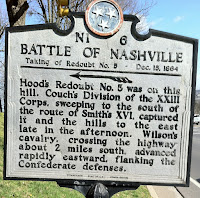
| The historical marker on Hillsboro Pike for Redoubt No. 5. |
There's not much good about this section of Hillsboro Pike—well, maybe except for the Shake Shack that serves an awesome strawberry shake topped with whipped cream 😅 and a Whole Foods market that sells a lot of swell but overpriced fruit and vegetables. As you can see below in the Google Street View, an apartment complex and a church occupy ground along the pike that once was a cornfield and pasture.
Bleh.
I zoomed in on the "Then" image by Kern hoping to find a stray musket or perhaps an artillery shell left over from the battle. Alas, no relics were found. But I discovered neat details: a dry-stack wall (some survive in the Nashville area); a small bridge over Sugartree Creek; and in the field at right, a residence and outbuildings. I'll check out deed/property records from the period.
 |
| Dry-stack walls in Nashville along Granny White Pike, similar to what once lined Hillsboro Pike. |
While I head over to Shake Shack, check out my posts on visits to what remains of Redoubts 3 and 4. And here's my Rambling column in Civil War Times magazine on Nashville hallowed ground today, what I like to call a "battlefield of the mind."
As always, let's keep history—and strawberry milkshakes topped with whipped cream—alive.
 |
| A cropped enlargment of Albert Kern's 1899 Kern photo shows dry-stack walls and a bridge on Hillsboro Pike. The historic road looks much different today. |
 |
| A residence and outbuildings appear on the right side of Hillsboro Pike in this cropped enlargement of Albert Kern's 1899 image. (CLICK ON IMAGES TO ENLARGE.) |
No comments:
Post a Comment